PEP will build scientific understanding and support decision-making to address threats to habitat and species.
The Peconic Estuary is home to some of the most valuable and rare habitats in the world. Physical alterations to the Peconic Estuary and its watershed such as navigational channel dredging, hardening of the shoreline with bulkheads and other erosion control structures, and clearing of land for roads and buildings all harm the habitats and living resources within and around the Estuary. At the headwaters of the Peconic River, the sensitive pine barrens ecosystem protects important drainage areas to the aquifer, which eventually outfall into the main estuary system. These alterations, along with pollution and warming waters, have led to the loss and degradation of critical habitats such as the pine barrens, eelgrass beds, marshes, and diadromous fish habitat.
The habitats of the Peconic Estuary face several key threats:
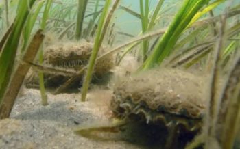
 Long-term monitoring in the Peconic Estuary indicates that water temperatures in the western section of the estuary no longer fall within the optimal range for eelgrass. Rising sea level is another threat to eelgrass survival in locations where seawalls and other types of shoreline hardening make it impossible for eelgrass beds to shift landward to remain in a favorable water depth. In addition, nutrient enrichment, algal blooms, water quality, boating and fishing practices, and shoreline stabilization structures are all collectively threatening the health and extent of eelgrass. The picture shows a boat propeller harming an eelgrass bed.
Over the last decade eelgrass restoration has been attempted at multiple sites within the Peconic Estuary. PEP is actively working on understanding suitable environmental conditions for eelgrass growth to better inform eelgrass protection and restoration efforts.
[caption id="" align="alignleft" width="533"]
Long-term monitoring in the Peconic Estuary indicates that water temperatures in the western section of the estuary no longer fall within the optimal range for eelgrass. Rising sea level is another threat to eelgrass survival in locations where seawalls and other types of shoreline hardening make it impossible for eelgrass beds to shift landward to remain in a favorable water depth. In addition, nutrient enrichment, algal blooms, water quality, boating and fishing practices, and shoreline stabilization structures are all collectively threatening the health and extent of eelgrass. The picture shows a boat propeller harming an eelgrass bed.
Over the last decade eelgrass restoration has been attempted at multiple sites within the Peconic Estuary. PEP is actively working on understanding suitable environmental conditions for eelgrass growth to better inform eelgrass protection and restoration efforts.
[caption id="" align="alignleft" width="533"] Check out these boater and eelgrass education signs that can be found around the estuary![/caption]
 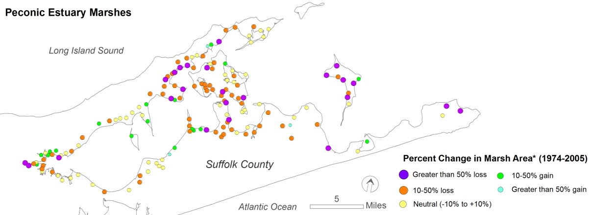 Of particular concern is the rapid decline of approximately 25 percent of high marsh habitat between 1974 and 2005. These trends suggest significant marsh drowning is occurring. Marsh drowning is related to the interacting effect of the failure of marsh accretion processes (such as deposition of organic sediments and accumulation of plant biomass) to keep pace with sea-level rise. Hardening of the shoreline, excess nutrients, tidal restrictions, and other land and human-use activities all affect marsh accretion and erosion processes and contribute to the degradation of these habitats. Marshes can migrate inshore gradually with rising sea levels, but the rapid rate at which sea level is now rising makes it difficult for them to migrate inshore fast enough.
 Additionally, in some cases, natural or man-made barriers—such as seawalls and other hardened shoreline structures—will prevent marshes for migrating inland. Tidal wetland loss means reduced feeding, breeding, and nursery habitats for waterfowl, wading birds, shorebirds, fish, and invertebrates. It also means a reduction in important ecosystem services, such as sediment retention, nutrient and organic matter recycling, and storm and flood buffering. Other threats to marsh habitat include excess nitrogen, the introduction of pollutants, and other invasive plants that outcompete with native marsh plants.
  In the late 1800s and early 1900s, dams were built on nearly all of Long Island’s freshwater tributaries for grist mills, cranberry bogs, and other industrial uses, and as property line demarcations. These dams cut off historic migratory routes for diadromous fish, notably river herring and American eels, blocking access to hundreds of acres of habitat. Other physical structures such as road culverts can also block access to freshwater habitats. River herring and American eel populations have declined over the past century, in part due to this loss of freshwater habitat. The decline of these diadromous fish has negative impacts on the health of the Peconic Estuary ecosystem. The movement of diadromous fish from salt to fresh water is especially important in transferring ocean-derived energy into estuarine, freshwater, and upland habitats. River herring and American eel also provide prey for countless species during their annual migration.
The Peconic Estuary Partnership has been working with its partners to restore historic access to freshwater habitat for diadromous fish by installing fish passage structures that allow fish to go around or over the dam, and replacing undersized road culverts with larger, fish-friendly culverts.
See this page for more information on the PEP's efforts to expand diadromous fish habitat in the watershed.
In the late 1800s and early 1900s, dams were built on nearly all of Long Island’s freshwater tributaries for grist mills, cranberry bogs, and other industrial uses, and as property line demarcations. These dams cut off historic migratory routes for diadromous fish, notably river herring and American eels, blocking access to hundreds of acres of habitat. Other physical structures such as road culverts can also block access to freshwater habitats. River herring and American eel populations have declined over the past century, in part due to this loss of freshwater habitat. The decline of these diadromous fish has negative impacts on the health of the Peconic Estuary ecosystem. The movement of diadromous fish from salt to fresh water is especially important in transferring ocean-derived energy into estuarine, freshwater, and upland habitats. River herring and American eel also provide prey for countless species during their annual migration.
The Peconic Estuary Partnership has been working with its partners to restore historic access to freshwater habitat for diadromous fish by installing fish passage structures that allow fish to go around or over the dam, and replacing undersized road culverts with larger, fish-friendly culverts.
See this page for more information on the PEP's efforts to expand diadromous fish habitat in the watershed.

Peconic Estuary Partnership provides program and project updates!
In 1997 the Peconic Estuary Partnership Habitat Restoration Workgroup was formed and charged with identifying important Peconic natural habitats with enhancement or restoration potential, developing overall habitat restoration goals, and identifying and prioritizing potential restoration projects. The end product was the “Habitat Restoration Plan for the Peconic Estuary” dated December 2000. This Habitat Restoration Plan was subsequently updated in 2009, in 2017 and again in 2020. Over the years, the Peconic Estuary Partnership has completed projects to restore a variety of habitat types, including beaches/dunes, grasslands, diadromous fish habitat, eelgrass, and wetlands.
Accanonac Harbor Wetland Restoration:
This project is based in partnership between PEP, The Nature Conservancy, The Town and Trustees of East Hampton as well as the regional group of experts, Salt Marsh Adaptation & Resiliency Teams, or SMARTeams. Over the past decade, SMARTeam members have piloted new techniques to address hydrologic dysfunction found within landscapes of marshlands of the North Atlantic Region.
Since 2016 Suffolk County Vector Control has been engaged with the Town of East Hampton, The Nature Conservancy, and several other community members to reduce the spraying of pesticides by removal of mosquito larvae in the Accabonac marsh complex. This community’s mosquito breeding program saved money, time, and pesticide exposure, and increased transparency between vector control and the community. This program’s data and Vector Control’s priorities are at the center of this design as the restoration approach strives to return the natural rise and fall of the tides, ushering in healthy native marsh vegetation to reduce the number of mosquito-breeding hotspot areas.
PEP and Suffolk County Health Services are currently leading the next phase of design and permitting. This is an opportunity for Accabonac Harbor to be exemplary in pushing forward the development of new and novel restoration approaches in order to combat sea level rise. The regional group, SMARTeams, has developed these methods which introduce an alternative to traditional high disturbance restoration.
Currently, contracts are executed, stakeholder meetings and workshops are in progress as plans are permits are being prepared for this restoration project. Please reach out to jade.blennau@stonybrook.edu if you are interested in this project's progress.
The Upper Mills Dam is the next major barrier to fish passage on the main stem of the Peconic River. In addition to the dam, USGS maintains a concrete weir two-hundred and fifty (250) feet downstream of the dam in order to measure the stage and discharge of the Peconic River, which also impedes fish passage. A feasibility and alternative analysis for fish passage at the Upper Mills Dam was completed in 2011. PEP is currently contracting with L.K. Mclean Associates P.C. to complete the engineering design and permitting services for construction of a fish passage at the Upper Mills Dam and Weir. This project will open 40 acres of historic spawning and maturation habitat for diadromous fish. The fish passage engineering design and permitting work is complete.
PEP is working with partners to secure construction funding for this project.
Click here to Learn about PEP’s Progress in Diadromous Fish Habitat Restoration.
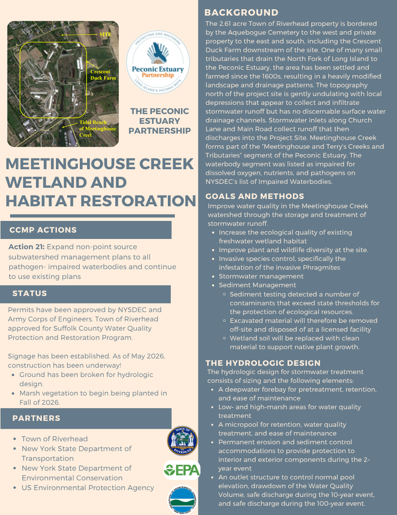
Meetinghouse Creek:
In 2019 PEP completed a conceptual design, with Land Use Ecological Services, Inc., for the priority habitat restoration project at Meetinghouse Creek, Riverhead, NY. Click here for the Meetinghouse Creek Wetland Restoration/ Construction Conceptual Design Plan.
This site is located at a large wetland area that forms the headwaters to Meetinghouse Creek in Riverhead, NY. Meetinghouse Creek is listed as an impaired waterbody on the NYSDEC Priority Waterbodies List. The wetland vegetation at this site is dominated by Phragmites.
The conceptual design recommendation is to construct a 1.2-acre stormwater wetland to treat stormwater runoff in the 5.6 acre contributing watershed. This will improve water quality in the downstream wetland and surface waters. Additionally, it will greatly increase the ecological quality of the habitat and improve plant and wildlife diversity.
Engineering Designs and Permitting for the habitat restoration project has been completed. Interfluve and Land Use Ecological Services, Inc., and Town of Riverhead completed the Engineering Designs, Permitting services, as well as EPA QAPP. Funds are being secured for implementation of this project.
Meeting House Creek Wetland and Habitat Restoration
In 2019 PEP completed a conceptual design, with Land Use Ecological Services, Inc., for the priority habitat restoration project at Narrow River Road, Southold, NY. Click here for the Narrow River Road Wetland Restoration Conceptual Design Plan.
Narrow River is a tributary of the Peconic Bay and flows south from the Town’s Whitcom Marsh Preserve under Route 25 and along the eastern side of Narrow River Rd in Orient, NY. An earthen dam was constructed after the 1938 hurricane to prevent tidal flooding of the lands north of the dam. The westernmost section of the dam blocked the tidal flow from Narrow River to the large meadow area north of the dam known as Broad Meadows and Whitcom Marsh Preserve north of Route 25.
Remediation of the culvert and earthen dam is needed to improve the tidal exchange throughout the extent of the river and increase the salinity of the river to promote the re-establishment of native vegetation and important waterfowl and wading bird habitat. The potential extent of the restoration area is 80 acres. The Town of Southold is currently working to secure bids for project implementation.
Paul Stoutenburgh Preserve is a Town owned 52 acre nature preserve on the west side of Arshamomaque Pond with an adjacent 7 acre County owned preserve, Arshamomaque Preserve. Several areas along the shoreline and interior have pockets of invasive Phragmites australis resulting in low quality wetlands. Invasive mile-a-minute weed has become established and is rapidly increasing in areas adjacent to tidal and fresh water wetland areas. The project site was nominated by the Town of Southold to be included in the Peconic Estuary Program Habitat Restoration Plan in 2013 and the project was prioritized for habitat restoration in 2016. Habitat restoration is recommended and is anticipated to involve the removal of the invasive species using currently accepted removal and restoration practices, and changes to drainage infrastructure in the area to make conditions less suitable for invasive vegetation.
The Paul Stoutenburgh Habitat Restoration Project contractor has completed an assessment of the hydrology of the southwest portion of the Paul Stoutenburgh Preserve and presented findings in stakeholder meetings and Southold Town Trustees. These hydrological plans and alternatives will be used for the Town Engineering Department to make data-driven decisions for implementation on their property. Culvert Amendment engineering plans are complete and permits drafted for Town submission.
The PEP is working with the NYSDEC and SUNY Stony Brook to analyze spatial and temporal trends in the Peconic Estuary finfish trawl survey dataset, and develop risk metrics from ecological relationships for the Peconic Estuary that examine whether local and regional environmental changes have increased the vulnerability of individual finfish and mobile invertebrate species, community assemblages, and ecosystem processes.
The ECOSIM is a quantitative modeling framework that can represent all major ecosystem functional groups and can be used to identify and assess structural changes in the ecosystem in response to environmental change. The proposed study will identify vulnerable species, critical habitats, and ecosystem properties within the Peconic Estuary. This information has direct application to decisions affecting the use, management, and conservation of the natural resources in the bay.
A SUNY Stony Brook is advertising for a post-doctoral position currently to complete the work. The expected completion period is March 2023.
Ground truthing for the 2020 Hardended Shoreline Assessment is ongoing in partnership with Cornell Cooperative Extension. 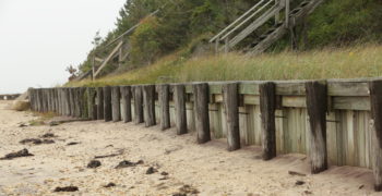
In partnership with Bradley Peterson, PhD. SoMAS, Stonybrook University and Joseph Tamborksi PhD., Department of Ocean & Earth Sciences, Old Dominion University
Restore America's Estuaries 2022 Coastal Watershed Grant Funding:
Find out more on our CWG webpage.
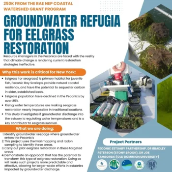
Rising water temperatures are restricting seagrass coverage to areas of increased oceanic
influence throughout the northeastern US. Resource managers are faced with the reality that
climate change is rendering many current restoration strategies ineffective. This project will
demonstrate the use of groundwater as thermal refugia in an emerging restoration strategy.
Using assessments of key parameters (e.g.: radon, groundwater discharge) and novel seagrass
transplant techniques, we will test and demonstrate an approach that has the potential to
transform this type of eelgrass restoration. Doing so will make such projects more predictable
and effective, allowing for larger-scale efforts in estuaries impacted by groundwater discharge.
PEP works with a number of partners to monitor the condition of essential habitats in the Peconic Estuary. We are constantly developing plans to improve our monitoring programs.
See here for the Peconic Estuary Partnership’s Ongoing Monitoring Programs.
Peconic Estuary Partnership has completed a Water Quality Monitoring Assessment with the assistance of CoastWise Partners, LLC. This goal of this assessment was to establish a Peconic Estuary Monitoring Strategy utilized by decision makers and to develop appropriate indicators of estuarine health, as well as ensure appropriate parameters are collected regularly to assess subsequent water quality
PEP has held multiple workshops and Technical Advisory Committee meetings with our main water quality monitoring program partners to review current water quality monitoring programs, discuss gaps in monitoring procedurals, and develop strategies to improve monitoring programs as well as reporting to better track trends and progress. CoastWise Partners has been a tremendous help in guiding the development of the updated monitoring strategy with additional annual water quality reports.
In May of 2020, the Peconic Estuary Partnership Technical Advisory Committee recommended approval of the Peconic Estuary Water Quality Monitoring Strategy, a required element of the Peconic Estuary Partnership’s 2020 Comprehensive Conservation and Management Plan. The Management Committee and Policy Committee approved it in June 2020, with the final document having been formally approved by the EPA and incorporated into the Peconic Estuary 2020 CCMP document.
The finalized PEP Water Quality Monitoring Strategy includes a summary of existing water quality monitoring programs in addition to an assessment of whether data collected by those programs can adequately track and detect changes in water quality needed to assess progress towards CCMP Goals. The Strategy also includes next steps to address gaps in data and/or information needed to fully assess progress towards CCMP Goals.
The goal of this project was to create a Peconic Estuary Monitoring Strategy that will be relevant for all decision makers and to develop appropriate indicators of estuarine health, and ensure appropriate parameters are collected on a temporal and spatial scale to assess these indicators.
PEP held multiple workshops and Technical Advisory Committee meetings with our main water quality monitoring program partners to review current water quality monitoring programs, discuss gaps, the new CCMP goals, and develop strategies to improve monitoring programs and reporting to better track trends and progress in relation to CCMP implementation. CoastWise Partners helped guide the development of the updated monitoring strategy with the end goal of annual water quality reports.
In May of 2020, the Peconic Estuary Partnership Technical Advisory Committee recommended approval of the Peconic Estuary Water Quality Monitoring Strategy, a required element of the Peconic Estuary Partnership’s 2020 Comprehensive Conservation and Management Plan. The Management Committee and Policy Committee approved it in June 2020 and the final document is being formally approved by the EPA and incorporated into the CCMP.
The finalized Strategy includes a summary of existing water quality monitoring programs and an assessment of whether data collected by those programs can adequately track and detect changes in water quality needed to assess progress towards CCMP Goals. The Strategy also includes Next Steps to address gaps in data and/or information needed to fully assess progress towards CCMP Goals.
Click here for the PEP Water Quality Monitoring Strategy.
Peconic Estuary Monitoring Collaborative helped to advise the completion of the next steps outlined in the PEP Water Quality Monitoring Strategy.
The Collaborative will continue to function as a sub-committee of the Technical Advisory Committee (TAC). This Collaborative is composed of main water quality monitoring programs in the Estuary, with members of NYSDEC, USGS, Suffolk County, and supplemental academic monitoring groups.
The Collaborative will function as a sub-committee of the Technical Advisory Committee (TAC) and is composed of main water quality monitoring programs in the Estuary, with members of NYSDEC, USGS, Suffolk County, and academic monitoring groups.
The Peconic Estuary faces ecological challenges such as coastal resilience to storm events, sea level rise, excess nutrients leading to harmful algal blooms, and loss of habitat. This project will utilize combinations of kelp, oysters, and seagrasses to tackle these issues.
The decline of eelgrass (Zostera marina L.) in the Peconic Estuary over the last 70 years has contributed to the degradation of the estuary as a whole. PEP has undertaken several initiatives to advance the protection and management of eelgrass in the Peconic Estuary. As of 2025, PEP has launched its seagrass monitoring program in partnership with researchers from Stony Brook University. This monitoring program continues to focus on collecting data pertaining to the health of the eelgrass beds at various sites throughout the Peconic Estuary. PEP continues to support aerial surveys of eelgrass and continue monitoring the successful work that has come from the Coastal Watershed Grant. PEP hopes that this continued work will assist New York State’s initiatives to create seagrass management areas in the near future.
For more information on eelgrass work in the Peconic Estuary, click here!
Sign up for News, Events and Information straight to your inbox.