PEP is making significant change. See here for accomplishments and current PEP projects.
Established in 1987 under the Clean Water Act, the National Estuary Program (NEP) operates through partnerships with EPA and other public and private sector entities to “identify, restore, and protect nationally significant estuaries of the United States.” The NEP hosts locally-based, stakeholder driven programs that are non-regulatory, collaborative initiatives working with the community to craft and implement action plans to solve environmental problems at the watershed level.
Established in 1992, the Peconic Estuary Partnership (PEP) integrates environmental and economic issues for all east-end towns and has brought over $13 million in federal grant funding to the Peconic Estuary watershed.
One major aspect of the Peconic Estuary Partnership’s leadership is its effective use of funds provided by EPA to leverage additional support.
The NEP’s exemplify efficient and effective governance. For every one dollar provided by the federal government, $19 is contributed by NEP’s non-federal partners. For example, the Peconic Estuary Partnership used its annual NEP grant to secure an additional $22 million in leveraged resources from public and private funders. The resources were used to help address Peconic Estuary’s priority problems, including: nutrients, pathogens, toxic chemicals, harmful algae, loss of critical habitats and natural resource threats.
Peconic Estuary Partnership provides program and project updates!
Check out the PEP Goal page to view projects PEP is moving forward!
Healthy Ecosystem with Abundant, Diverse Wildlife
The PEP provides leadership and coordination to restore and maintain the water quality and ecological integrity of the Peconic Bays and the surrounding watershed. The work of the PEP protects water quality and in turn improves the condition of shellfish, fish, and wildlife. These efforts are critical to preserving the quality of life for all Suffolk County residents and promote local and regional economies that increasingly rely on tourism, recreational fishing, boating, and other water-dependent industries.
The PEP is a comprehensive, regional, watershed-based program, the perfect mechanism to implement programs and initiatives that can result in measurable water quality improvements. PEP’s watershed management plan, or Comprehensive Conservation Management Plan, represents a regional consensus on the water quality improvement action agenda. As a result, the PEP helps to shape other regional water quality projects and programs and increases Federal and State funding attention on those priority actions. Stakeholder participation in this regional water quality planning effort is beneficial to all as it incorporates the local interests very effectively into a regional strategy.
Water Quality Improvements
Nitrogen Management has always been an important part of the Peconic Estuary Partnership's Strategy to protect and restore water quality in the Peconic Estuary. Initially focused on point sources and direct discharges, many important steps were taken to reduce nitrogen loading to the Peconic Estuary including the establishment of the Vessel Waste No-Discharge Zone in 2002 and The PEP has supported the establishment of the Suffolk County Fertilizer Reduction Law in 2007 in an effort to reduce nitrogen loads from fertilizer applications. Additionally, in 2007 NY State developed a nitrogen pollutant load limit for the Peconic Estuary called the Total Maximum Daily Load for Nitrogen for the Peconic Estuary . This pollutant load limit, Total Maximum Daily Load (TMDL), for Nitrogen is a pollutant diet that the waterbody must comply with to address the poor water quality in the western Peconic Estuary. The TMDL determined the amount of pollutant load that can be discharged from point sources discharges (such as outfall pipes) and pollution sources that are diffuse (termed “non-point sources”) to achieve or maintain water quality standards. The introduction of Nitrogen TMDL supported the major upgrades to Sewage Treatment Plants within the Estuary. The Peconic Estuary Partnership was influential in moving the 2016 Riverhead Sewage Treatment Plant upgrade and reuse project forward to reuse highly-treated wastewater to irrigate the Indian Island Golf Course. Furthermore, PEP has developed 12 Subwatershed Management Plans for the Peconic Estuary that identify cost‑effective strategies to help reduce pathogen and stormwater runoff pollution and improve water quality (2006- Developed 5 Subwatershed Management Plans, 2013- Developed 7 Subwatershed Management Plans). Many of the Towns have successfully implemented projects identified in the Subwatershed Management Plans! The PEP worked with the Village of Sag Harbor and Nelson Pope and Voorhis, LLC. to implement a non-point source pollution management project at Havens Beach in Sag Harbor, NY in fall of 2020, involving the construction of two native plant rain gardens at Havens Beach to treat stormwater that would otherwise flow across the beach and/ or through an existing discharge pipe directly to Sag Harbor Bay.
To improve collaboration on stormwater pollution mitigation, in 2015 PEP and the East End municipalities entered into an Intermunicipal Agreement, forming the Peconic Estuary Protection Committee, to reduce stormwater runoff and pollution from septic system discharges, agricultural and residential fertilizer, groundwater flows, illegal dumping, floatable debris, and boat waste. The Peconic Estuary Partnership worked with the Peconic Estuary Protection Committee to develop a Quality Management Plan (QMP) and a foundation for Quality Assurance Project Plans (QAPP) for Water Quality Monitoring in the Peconic Estuary available in 2021 to enable the Peconic Estuary Protection Committee (PEPC) and partners to quantify water quality parameters so that equally comparable data can be collected and shared.
The PEP has fostered sustainable practices in backyards on the East End, the Homeowner Rewards Program has helped 71 property owners since 2014 complete sustainable upgrades to their yards by installing native plant gardens, rain gardens or rain barrels. To date 67,453 square feet of native plant garden, 3,300 square feet of rain garden, and 67 rain barrels have been installed through the program. Reducing fertilizer and pesticide use and reducing water use. A Demonstration Rain Garden was installed by PEP and the Town of Riverhead in 2016 on Heidi Behr Way in downtown Riverhead to collect and filter rainwater and snowmelt before the water runs into the Peconic River, the plants will help filter pollutants and our educational sign will help inform the public about the benefits of rain gardens.
The entire Peconic Estuary was designated as a federally recognized Vessel Waste No Discharge Zone (NDZ) in 2002 in order to help protect our shellfish beds and keep our waters safe and clean for swimming and recreation. In a NDZ, treated and untreated discharges from marine toilets are prohibited. To ensure compliance with the NDZ, boaters must modify their “heads” to prevent discharges.
The PEP has supported the establishment of the Suffolk County Fertilizer Reduction Law in 2007 in an effort to reduce nitrogen loads from fertilizer applications.
In 2007 NY State developed a nitrogen pollutant load limit for the Peconic Estuary called the Total Maximum Daily Load for Nitrogen for the Peconic Estuary . This pollutant load limit, Total Maximum Daily Load (TMDL), for Nitrogen is a pollutant diet that the waterbody must comply with to address the poor water quality in the western Peconic Estuary. The TMDL determined the amount of pollutant load that can be discharged from point sources discharges (such as outfall pipes) and pollution sources that are diffuse (termed “non-point sources”) to achieve or maintain water quality standards. The introduction of Nitrogen TMDL supported the major upgrades to Sewage Treatment Plants within the Estuary.
PEP has developed 12 Subwatershed Management Plans for the Peconic Estuary that identify cost‑effective strategies to help reduce pathogen and stormwater runoff pollution and improve water quality (2006- Developed 5 Subwatershed Management Plans, 2013- Developed 7 Subwatershed Management Plans). Many of the Towns have successfully implemented projects identified in the Subwatershed Management Plans!
The PEP has fostered sustainable practices in backyards on the East End, the Homeowner Rewards Program has helped 71 property owners since 2014 complete sustainable upgrades to their yards by installing native plant gardens, rain gardens or rain barrels. To date 67,453 square feet of native plant garden, 3,300 square feet of rain garden, and 67 rain barrels have been installed through the program. Reducing fertilizer and pesticide use and reducing water use.
To improve collaboration on stormwater pollution mitigation, in 2015 PEP and the East End municipalities entered into an Intermunicipal Agreement, forming the Peconic Estuary Protection Committee, to reduce stormwater runoff and pollution from septic system discharges, agricultural and residential fertilizer, groundwater flows, illegal dumping, floatable debris, and boat waste.
The Peconic Estuary Partnership was influential in moving the 2016 Riverhead Sewage Treatment Plant upgrade and reuse project forward to reuse highly-treated wastewater to irrigate the Indian Island Golf Course. In summer of 2016, after nearly 20 years of planning, the Riverhead Sewer District celebrated the completion of its upgrade and the First-on-Long-Island “Water Resource Recovery Facility”. The Riverhead Town Sewage Treatment Plant will reuse highly-treated wastewater to irrigate the Indian Island Golf Course. This will divert approximately 1.4 tons of nitrogen per year from entering the Peconic Estuary via the Riverhead Sewage Treatment plant outfall pipe, and the improved treatment technology at the plant will help to further reduce the nitrogen load to the Estuary. Additionally, this will save an estimated 350,000 gallons of water each summer day because now instead of using water from drinking water supply wells to irrigate the course golf course, the highly-treated wastewater will be used instead. Using the treated wastewater will also reduce the amount of fertilizer needed at the golf course, thereby reducing the nitrogen load contributed by surface water runoff. View & Download the Riverhead Purple Pipes Booklet 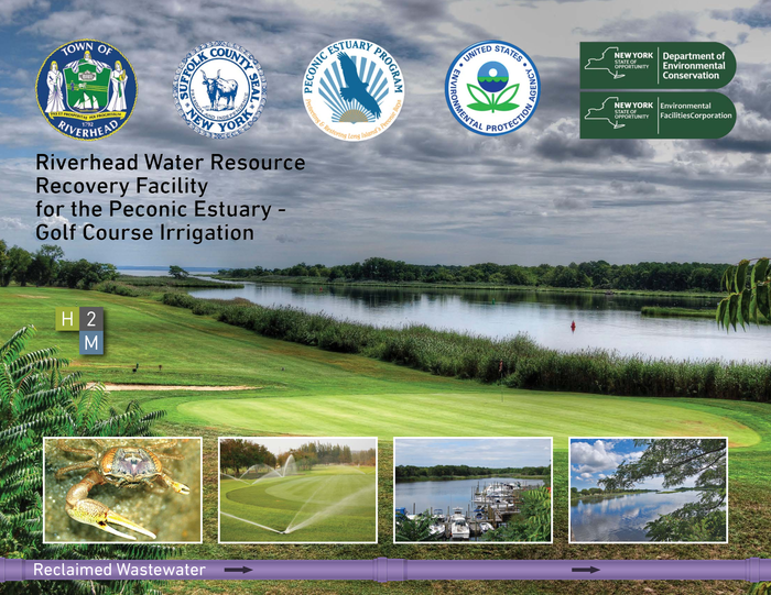
With the help of the Town of Riverhead and the Town of Riverhead Engineering Department, a demonstration rain garden was installed on Heidi Behr Way in downtown Riverhead on the Peconic River Waterfront in 2016. On Earth Day 2016, volunteers came down to the demonstration rain garden to help plant native vegetation and learn about the benefits of using native plants. This garden will collect and filter rainwater and snowmelt before it runs into the Peconic River, the plants will help filter pollutants and our educational sign will help inform the public about the benefits of rain gardens. Stop down on Heidi Behr Way in Riverhead to visit PEP’s rain garden! Learn more about the Rain Garden here!
The PEP worked with the Village of Sag Harbor and Nelson Pope and Voorhis, LLC. to implement a non-point source pollution management project at Havens Beach in Sag Harbor, NY. The project was completed in the fall 2020 and involved utilizing green infrastructure best management practices to treat stormwater that would otherwise flow across the beach and/ or through an existing discharge pipe directly to Sag Harbor Bay. The project furthers the goals of the Village of Sag Harbor Water Quality Improvement Project Plan which was adopted in 2016.
Two native plant rain gardens were established at Havens Beach and an educational sign was installed at the site to describe the benefits of rain gardens and native plants. The main purpose of the rain garden is to provide treatment of solids, metals, nutrients, hydrocarbons and pathogens from stormwater runoff along Havens Beach Road. The waterfront stormwater retention and filtration system using native plants is estimated to reduce Total Nitrogen bby 7.6 lbs/ year, Total Phosphorus, by 0.8 lbs/year, Total Suspended Solids by 460 lbs/ year and bacteria.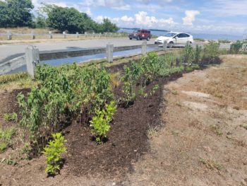
In 2021, The Peconic Estuary Partnership completed work with the Peconic Estuary Protection Committee and Tetra Tech, Inc. to develop a Quality Management Plan (QMP) and a foundation for Quality Assurance Project Plans (QAPP) for Water Quality Monitoring in the Peconic Estuary. The project goal was to develop a NYSDEC and EPA approved QAPP to enable the Peconic Estuary Protection Committee (PEPC) and partners to quantify water quality parameters so that equally comparable data can be collected and shared for uses such as to identify and prioritize subwatersheds in the Peconic Estuary that should be targeted for water quality improvement activities; ensure water bodies are properly listed on the NYS Impaired Waters list; and help the PEPC members and partners, including the Peconic Estuary Partnership, assess the current baseline in water quality, and effectiveness of water quality improvement interventions over time.
PEP and USGS developed a Solute Transport Model project for nitrogen in the Peconic Estuary to help calculate the loads to the estuary by each jurisdiction and sub-watershed. The USGS-PEP Solute Transport Model Project will estimate the time-varying discharge of nitrogen into fresh and coastal waters within the Peconic Estuary watershed. Thanks to this model, it is possible to run a limited set of scenarios to estimate resulting nitrogen loading rates over time. The model will be finalized in 2023 and shared with stakeholders
The Peconic Estuary Nitrogen Load Reduction BMP and Cost Assessment project is an important tool developed to aid the Peconic Estuary Partnership and its stakeholders in achieving nitrogen load reductions to groundwater within the watershed. The tool determines the cost per pound of nitrogen reduction for a multitude of Best Management practices (BMPs) available in the Peconic Estuary Watershed. The BMPs take into account the geographical, environmental, and climate-based factors in eastern Suffolk County and have been carefully chosen to mitigate nitrogen from primary sources within the Peconic Estuary watershed. They are grouped by the following categories: septic waste, surface runoff, potential agriculture, water reuse, septic waste experimental, groundwater, turf grass fertilizer and bioextraction.
Habitat Improvements
Cited as one of the “Last great places in the Western Hemisphere,” the Peconic Estuary contains a rich mosaic of natural communities, all of which are important to the ecology and productivity of this ecosystem. There is a larger percentage of undisturbed habitats and a greater diversity of natural communities within the Peconic Estuary watershed, on a per unit area basis, than anywhere else in the coastal zone of New York State.
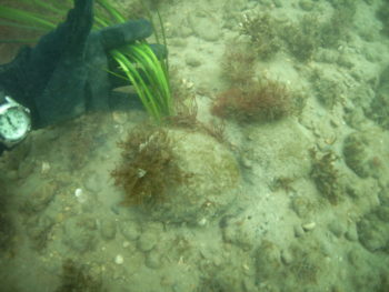
The Peconic Estuary Partnership has worked with our partners to protect and restore habitats in the Peconic Estuary watershed and protect the ecosystem services they provide. The Peconic Estuary Partnership Habitat Restoration Plan prioritizes habitat restoration projects and since 2000, 27 habitat restoration projects have been completed. Completed projects include 2 beach restorations, 2 shorebird habitat restorations, 7 wetland restoration projects, 2 phragmites control project, 1 grassland restoration project, 3 water quality improvement projects, 2 diadromous fish habitat restoration projects, 6 shellfish restoration projects, and 2 eelgrass restoration projects. Monitoring data collected and reported under the Peconic Estuary Partnership Long-Term Eelgrass Monitoring Program indicated that the Bullhead Bay eelgrass bed, the western-most bed in the Peconic Estuary, was in severe decline and was being impacted greatly by physical disturbances, especially shellfish harvesting. This information was presented to the Southampton Trustees, who then designated the bed as an eelgrass sanctuary to prohibit shellfishing within its boundaries in 2009. To promote shellfish restoration in 2013, the Hard Clam and American Oyster Enhancement and Restoration in Lake Montauk project was completed which was funded in part by the Peconic Estuary Partnership. The project involved growing and seeding one million clams and 500,000 oysters into Lake Montauk during 2012 and 2013.
The PEP supported the completion of the Long Island Tidal Wetlands Trends Analysis in 2015 which measured wetlands loss and changes in marsh condition within the Long Island Sound, Peconic, and South Shore estuaries including all or parts of Westchester, Bronx, Queens, Nassau, and Suffolk Counties. The results of this project are used by environmental managers, conservation advocates and elected officials across a variety of regulatory agencies, environmental organizations, and governments. In support of improving populations of diadromous fish to date the Peconic Estuary Partnership has helped to open up 35 acres of freshwater habitat on the Peconic River with the completion of the Grangebel Park Natural Fishway in 2010 and Edwards Avenue fish passage in 2016.
To move forward priority habitat restoration projects, PEP has developed 9 Conceptual Designs to assist Towns in taking steps towards habitat restoration. A conceptual design for Shell Beach Native Vegetation Restoration was completed in 2012, and a conceptual design for Napeague Harbor Circulation Enhancement was completed in 2013, additionally in 2013 PEP funded 3 conceptual designs for fish passage at Forge Road Dam, Ligonee Brook, and Moore’s Drain.
In 2019 conceptual habitat restoration designs were developed for the following 4 identified priority sites: Southold: Narrow River Road Wetland Restoration, Southampton: Iron Point Wetland Restoration, East Hampton: Lake Montauk Alewife Access and Habitat Enhancement, Riverhead: Meetinghouse Creek Main Road Wetland Construction/Restoration.
In 2019 the Widows Hole Preserve Living Shoreline Project was completed in Greenport with Peconic Land Trust and Cornell Cooperative Extension of Suffolk County. This is the first living shoreline project in the Peconic Estuary. Click here to view the project story: Widow’s Hole Preserve Story Map
In 2019 the Seagrass Bio-optical Model was developed in cooperation with The Research Foundation of SUNY Stony Brook to provide site specific information on what areas of the Peconic Estuary provide suitable habitat for eelgrass to guide future eelgrass protection and restoration projects. The final report is linked here: Living on the edge- Analysis of Zostera marina and the potential for restoration in Peconic Bay (Long Island, NY) (2020)
Monitoring data collected and reported under the Peconic Estuary Partnership Long-Term Eelgrass Monitoring Program indicated that the Bullhead Bay eelgrass bed, the western-most bed in the Peconic Estuary, was in severe decline and was being impacted greatly by physical disturbances, especially shellfish harvesting. This information was presented to the Southampton Trustees, who then designated the bed as an eelgrass sanctuary to prohibit shellfishing within its boundaries in 2009.
To promote shellfish restoration in 2013, the Hard Clam and American Oyster Enhancement and Restoration in Lake Montauk project was completed which was funded in part by the Peconic Estuary Partnership. The project involved growing and seeding one million clams and 500,000 oysters into Lake Montauk during 2012 and 2013.
In support of improving populations of diadromous fish to date the Peconic Estuary Program has helped to open up 35 acres of freshwater habitat on the Peconic River with the completion of the Grangebel Park Natural Fishway in 2010 and Edwards Avenue fish passage in 2016.
The PEP supported the completion of the Long Island Tidal Wetlands Trends Analysis in 2015 which measured wetlands loss and changes in marsh condition within the Long Island Sound, Peconic, and South Shore estuaries including all or parts of Westchester, Bronx, Queens, Nassau, and Suffolk Counties. The results of this project are used by environmental managers, conservation advocates and elected officials across a variety of regulatory agencies, environmental organizations, and governments.
To move forward priority habitat restoration projects, PEP has developed 9 Conceptual Designs to assist Towns in taking steps towards habitat restoration. A conceptual design for Shell Beach Native Vegetation Restoration was completed in 2012, and a conceptual design for Napeague Harbor Circulation Enhancement was completed in 2013, additionally in 2013 PEP funded 3 conceptual designs for fish passage at Forge Road Dam, Ligonee Brook, and Moore’s Drain.
In 2019 conceptual habitat restoration designs were developed for the following 4 identified priority sites, implementation of these projects are all in progress in some phase:
Southold: Narrow River Road Wetland Restoration
Southampton: Iron Point Wetland Restoration
East Hampton: Lake Montauk Alewife Access and Habitat Enhancement
Riverhead: Meetinghouse Creek Main Road Wetland Construction/Restoration
In 2019, the Widows Hole Preserve Living Shoreline Project was completed, this is the first living shoreline project in the Peconic Estuary.
PEP worked with Peconic Land Trust and Cornell Cooperative Extension of Suffolk County to create a living shoreline on Peconic Land Trust's Widow's Hole Preserve in Greenport, NY. It will be monitored to assess its efficacy in providing storm resilience and coastal habitat, and the changes in elevation of the shoreline over time to identify loss/gain of sand and the growth of smooth cordgrass (Spartina alterniflora) and America beachgrass (Ammophila).
Click here to view the project story: Widow’s Hole Preserve Story Map
Click here to watch Peconic Land Trust's webinar "The Living Shoreline" to learn how this collaboration led to this successful living shoreline project, and why projects like these should be abundant in the future. Panelists included PEP's State Coordinator, Elizabeth Hornstein; Steve Schott, Marine Botany/Habitat Restoration Specialist at Cornell Cooperative Extension Marine Program; and Matt Swain, Stewardship Director at the Peconic Land Trust. The webinar was moderated by Dr. Kathleen Fallon, Coastal Processes and Hazards Specialist with New York Sea Grant.
In 2019, the Seagrass Bio-optical Model was developed in cooperation with The Research Foundation of SUNY Stony Brook to provide site specific information on what areas of the Peconic Estuary provide suitable habitat for eelgrass to guide future eelgrass protection and restoration projects.
The final report is linked here: Living on the edge- Analysis of Zostera marina and the potential for restoration in Peconic Bay (Long Island, NY) (2020)
An ArcGIS tool and Story Map is being developed to share the results with our stakeholders.
In 2019 PEP completed a conceptual design, with Land Use Ecological Services, Inc., for the priority habitat restoration project at Lake Montauk, East Hampton NY. Click here for the East Hampton: Lake Montauk Alewife Access and Habitat Enhancement Conceptual Design Plan.
The goal of the conceptual habitat restoration design plan is to restore connectivity for diadromous fish species between Lake Montauk and Big Reed Pond by replacing an undersized culvert, and between Lake Montauk and Stepping Stones Pond by replacing an undersized, impassable culverts under Old West Lake Drive and removing debris.
Suffolk County Capital funds have been secured to replace the culvert that leads to Big Reed Pond and PEP staff will be working with Suffolk County parks to complete the permitting and construction. PEP staff are also working with partners to secure funding to complete engineering design plan and construction of the culvert leading to Stepping Stones Pond.
PEP worked with Peconic Land Trust and Cornell Cooperative Extension (CCE) of Suffolk County to create a living shoreline on Peconic Land Trust's Widow's Hole Preserve in Greenport, NY. This is the first living shoreline project to be completed in the Peconic Estuary. It will be monitored to assess its efficacy in providing storm resilience and coastal habitat, and the changes in elevation of the shoreline over time to identify loss/gain of sand and the growth of smooth cordgrass (Spartina alterniflora) and America beachgrass (Ammophila) Click here to view the project story: Widow’s Hole Preserve Story Map.
The Seagrass Bio-optical Model has been developed in cooperation with The Research Foundation of SUNY Stony Brook to provide site specific information on what areas of the Peconic Estuary provide suitable habitat for eelgrass to guide future eelgrass protection and restoration projects. This project will lead to a better understanding of specific light and temperature requirements for eelgrass in the Peconic Estuary (PE). This is the critical next step towards understanding the threats to the eelgrass community and where restoration projects have the best probability of success. The final report is linked below:
The Seagrass Restoration Map and Tool will be posted here when available to share the results with our stakeholders.
Click here for the presentation on the final Seagrass Bio-Optical Model: Living on the edge- analysis of Z. marina and potential for restoration- Kaitlyn O'Toole (2020).
The status and trends of living resources are closely related to the amount of land preserved in the Peconic Estuary. Benefits to land protection include preserving unique species and natural communities, and controlling nutrient and pollution loads to the Estuary. In addition, the public has exhibited a strong attachment to the natural resources and amenities provided by the Peconic Estuary region. The Peconic Estuary Partnership developed a 2004 Critical Lands Protection Strategy (CLPS) that outlined land still available for development that also meet certain criteria used to determine land protection priorities. The Partnership shares this information with State and local agencies so that it can be used to make land acquisition decisions. Since 2006, approximately 2,443 acres of land have been protected in the Peconic Estuary watershed. The most significant source of funding for land protection is the Community Preservation Fund (CPF), administered by the five East End towns. This funding is supplemented by County and State governments, and not-for-profit organizations (especially The Nature Conservancy and the Peconic Land Trust). 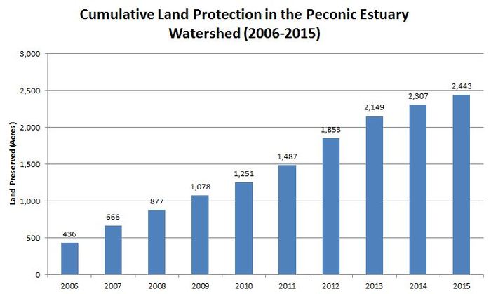 In 2019 the Critical Lands Protection Strategy was updated to continue protecting land for habitat and water quality protection, adaptation to sea level rise and groundwater protection. PEP worked with Anchor QEA, LLC. to re-evaluate the original prioritization of the Critical Lands Protection Strategy (CLPS) and the lands within the watershed were evaluation and prioritized considering climate change impacts. The 2019 Critical Lands Protection Strategy is included here in the 2019 Peconic Estuary Partnership Climate Vulnerability Assessment and Action Plan.
See here for the interactive Critical Lands Protection Strategy and Ranking Tool Story Map!
The decline of eelgrass (Zostera marina L.) in the Peconic Estuary over the last 70 years has contributed to the degradation of the estuary as a whole. The PEP has undertaken several initiatives to advance the protection and management of eelgrass in the Peconic Estuary. Since its inception, the PEP has supported a Long Term Eelgrass Monitoring Program conducted by Cornell Cooperative Extension’s Marine Program. This monitoring program, has focused on collecting data pertaining to the health of the eelgrass beds at various sites throughout the Peconic Estuary. PEP also conducted aerial surveys of eelgrass in 2014 to map and identify changes in the extent of the resource over time. In 2009, an Eelgrass Management Plan was adopted to provide a nesting ground for discussion, theories, and new actions necessary to minimize impacts to eelgrass and to provide a suitable environment for eelgrass to exist.
Below are the most recent Long-Term Eelgrass Monitoring Reports:
Peconic Estuary Program 2019 Long-Term Eelgrass Monitoring Program Report
Peconic Estuary Program 2018 Long Term-Term Eelgrass Monitoring Program Report
The Woodhull Dam is the next major barrier to fish passage on the Little River. Providing permanent fish passage at Woodhull Dam will create access to 95 acres of prime spawning habitat within Wildwood Lake. Wildwood Lake is located within preserved lands and would provide high quality, protected habitat. Funding for the construction of the dam was awarded to Suffolk County Parks/PEP through a NYSDEC Water Quality Improvement Project (WQIP) Grant, the Suffolk County Water Quality Protection and Restoration Program (WQPRP) grant and the United States Fish and Wildlife Service (USFWS). The project includes the construction and installation of a combination Denil pass and step pool fish passage and eel passage through the dam bypassing the existing culvert, with a video monitoring and fish counter system.
Click here to Learn about PEP’s Progress in Diadromous Fish Habitat Restoration. See below for the fish and eel passage design: 
The Upper Mills Dam is the next major barrier to fish passage on the main stem of the Peconic River. In addition to the dam, USGS maintains a concrete weir two-hundred and fifty (250) feet downstream of the dam in order to measure the stage and discharge of the Peconic River, which also impedes fish passage. A feasibility and alternative analysis for fish passage at the Upper Mills Dam was completed in 2011. PEP is currently contracting with L.K. Mclean Associates P.C. to complete the engineering design and permitting services for construction of a fish passage at the Upper Mills Dam and Weir. This project will open 40 acres of historic spawning and maturation habitat for diadromous fish. The fish passage engineering design and permitting work is complete.
Click here to Learn about PEP’s Progress in Diadromous Fish Habitat Restoration.
PEP is currently working with partners to secure construction funding for this project.
Land Protection
The Peconic Estuary Partnership developed the Critical Lands Protection Strategy in 2004 which supported the establishment and implementation of the Community Preservation Fund to protect land from development and preserve the health of the Peconic Estuary. The Community Preservation Fund was established in 1998 and managed by the East End towns for the protection of farmland, open space, and community character. The CPF is a one-time real estate transfer tax of 2% on improved or vacant property. In 2016, voters extended the CPF to 2050 and approved an amendment allowing towns to invest up to 20% of the funds in water quality improvement projects. With an agreement that 10% of that 20% could be allocated to the Peconic Estuary Partnership. This coordinated effort resulted in a total of 4,045 acres of land protected in the watershed to date. In 2019 the Critical Lands Protection Strategy was updated to continue protecting land for habitat and water quality protection, adaptation to sea level rise and groundwater protection. The lands within the watershed were evaluation and prioritized considering climate change impacts. The 2019 Critical Lands Protection Strategy is included here in the 2019 Peconic Estuary Partnership Vulnerability Assessment and Action Plan.
See here for the interactive 2019 Peconic Estuary Partnership Vulnerability Assessment and Action Plan.
As of Fall 2019, the following land protection statistics were calculated in the 2019 Critical Lands Protection Strategy Update:
Of the 10,215 parcels that are undeveloped within the Peconic Estuary watershed (making up approximately 56,667 acres), 4,045 parcels are already protected (making up approximately 40,253 acres). There are 6,170 undeveloped parcels that are still unprotected (making up or 16,444 acres).
The Community Preservation Fund was established in 1998. The CPF is a public program managed by the East End towns for the protection of farmland, open space, and community character. The CPF is a one-time real estate transfer tax of 2% on improved or vacant property. In 2016, voters extended the CPF to 2050 and approved an amendment allowing towns to invest up to 20% of the funds in water quality improvement projects. With an agreement that 10% of that 20% could be allocated to the Peconic Estuary Partnership.
The Peconic Estuary Partnership developed the Critical Lands Protection Strategy in 2004 which supported the establishment and implementation of the Community Preservation Fund to protect land from development and preserve the health of the Peconic Estuary. This coordinated effort resulted in a total of 4,045 acres of land protected in the watershed to date.
In 2019, the Critical Lands Protection Strategy was updated to continue protecting land for habitat and water quality protection, adaptation to sea level rise and groundwater protection. The lands within the watershed were evaluation and prioritized considering climate change impacts. The 2019 Critical Lands Protection Strategy is included here in the 2019 Peconic Estuary Partnership Climate Vulnerability Assessment and Action Plan.
See here for the interactive Critical Lands Protection Strategy and Ranking Tool Story Map!
As of Fall 2019, the following land protection statistics were calculated in the 2019 Critical Lands Protection Strategy Update:
Of the 10,215 parcels that are undeveloped within the Peconic Estuary watershed (making up approximately 56,667 acres), 4,045 parcels are already protected (making up approximately 40,253 acres). There are 6,170 undeveloped parcels that are still unprotected (making up or 16,444 acres).
Resiliency and Adaptability
The Peconic Estuary faces numerous pressures including development, habitat loss, and nutrient loading. Sea level rise (SLR), more frequent and more intense storms, and changing weather patterns are affected as well as the human responses to them. All have the potential to further degrade water and habitat quality and lead to greater habitat loss and fragmentation. To address these issues, in 2016 PEP embarked on a Climate Ready Assessment (CRA) Project to incorporate climate change into an updated CLPS, to conduct a risk-based climate change vulnerability assessment, and to develop an adaptation action plan consistent with USEPA’s Climate Ready Estuaries Program. In 2019, The Peconic Estuary Partnership created a guide for the municipalities and resources managers in the Peconic Estuary and the Shinnecock Indian Nation. Here is the 2019 Peconic Estuary Partnership Climate Vulnerability Assessment and Action Plan. Here is the 2019 Shinnecock Indian Nation Climate Vulnerability Assessment and Action Plan.
Peconic Estuary Partnership worked with Cornell Cooperative Extension of Suffolk County to complete a demonstration living shoreline project at the Suffolk County Marine Environmental Learning Center (SCMELC) in Southold, NY. The project incorporates smooth cordgrass and ribbed mussels and will be evaluated to determine its ability to provide storm resilience and coastal habitat, but also the shoreline’s effectiveness in reducing nitrogen and pathogen inputs to the Peconic Estuary. See here for the SCMELC Living Shoreline project page.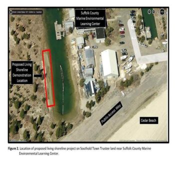
In 2019 the Critical Lands Protection Strategy was updated to have the lands within the watershed evaluated and prioritized. PEP is currently working on a 2026 update!
See the interactive Climate-based Critical Lands Protection Strategy and Ranking Tool Story Map!
Monitoring the Estuary’s Health
Since PEP’s inception the program has supported the robust surface water quality monitoring in the Peconic Estuary run by the Suffolk County Department of Health Services Bureau of Marine Resources. Through PEP funding, the water quality monitoring program conducted by the Suffolk County Department of Health Services (SCDHS) Office of Ecology includes monthly monitoring at 38 Peconic surface water quality stations throughout the year, periodic monitoring of 26 point source and stream stations. To compliment the Suffolk County Water Quality Monitoring Program, in 2012 the PEP established 2 water quality monitoring stations in the Peconic Estuary which are maintained by the United States Geological Survey and provide continuous information on the state of the water quality in the estuary. To keep a pulse on the pollution impacting the Estuary from the atmosphere, since 2003 the Peconic Estuary Partnership has been monitoring the atmospheric deposition of nitrogen in the Peconic Estuary watershed, through our participation in the National Atmospheric Deposition Program. Since 1997, PEP has supported Cornell Cooperative Extension of Suffolk County long-term monitoring of eelgrass survival and measurements of seagrass extent every year. In addition to supporting the above monitoring programs, the PEP provides many opportunities for citizens to get involved by attending an educational event or volunteering through our ongoing citizen science programs. PEP coordinates four citizen science programs that focus on collecting information on horseshoe crabs, alewife, and terrapins. PEP's Fishing Line Recycling Program is another helpful way that the public can help the PEP reduce excess fishing line from harming marine life and help the PEP monitor the areas where the fishing line receptacles are or are still needed.
Since PEP’s inception the program has supported the robust surface water quality monitoring in the Peconic Estuary run by the Suffolk County Department of Health Services Bureau of Marine Resources. Through PEP funding, the water quality monitoring program conducted by the Suffolk County Department of Health Services (SCDHS) Office of Ecology includes monthly monitoring at 38 Peconic surface water quality stations throughout the year, periodic monitoring of 26 point source and stream stations.
Since 1997, PEP has supported Cornell Cooperative Extension of Suffolk County Long-term monitoring of eelgrass survival and measurements of seagrass extent every year.
To keep a pulse on the pollution impacting the Estuary from the atmosphere, since 2003 the Peconic Estuary Partnership has been monitoring the atmospheric deposition of nitrogen in the Peconic Estuary watershed, through our participation in the National Atmospheric Deposition Program.
To compliment the Suffolk County Water Quality Monitoring Program, in 2012 the PEP established three water quality monitoring stations in the Peconic Estuary which are maintained by the United States Geological Survey and provide continuous information on the state of the water quality in the estuary.
In addition to supporting the above monitoring programs, the PEP provides many opportunities for citizens to get involved by attending an educational event or volunteering through our ongoing citizen science programs. PEP coordinates four citizen science programs that focus on collecting information on horseshoe crabs, alewife, and terrpains. PEP's Fishing Line Recycling Program is another helpful way that the public can help the PEP reduce excess fishing line from harming marine life and help the PEP monitor the areas where the fishing line receptacles are or are still needed.
Peconic Estuary Partnership measures the surface elevation of the salt marsh at Indian Island County Park, Hubbard County Park, and Cedar Beach of Southold Town. There are multiple elevation tables at each site that measure marsh accretion or subsidence, natural processes that are influenced by sea-level rise, changes in sediment loading, increasing temperatures, and other consequences of climate change.
Monitoring is conducted twice annually, with data contributing to local and regional understanding of the status and future of salt marsh systems in a changing world.
Marine and estuarine systems face a myriad of stressors ranging from eutrophication, habitat alteration, overfishing to climate change. Since 1987, the New York State Department of Environmental Conservation has conducted an extensive trawl survey in the Peconic Estuary. PEP and SBU partnered with NYSDEC analyze the spatial and temporal trends in the Peconic Estuary finfish trawl survey dataset and develop risk metrics from ecological relationships for the Peconic Estuary that examine whether local and regional environmental changes have increased the vulnerability of individual finfish and mobile invertebrate species, community assemblages, and ecosystem processes. This survey is carried out May through October with a 4.9-meter semi-balloon otter trawl. Sixteen stations are chosen weekly from a block grid of 77 units, each 1’ latitude by 1’ longitude in size. On average, 381 tows are collected each year. Assessing the vulnerability of species and communities to environmental change in the Peconic Estuary has direct application to decisions affecting the use, management, and conservation of the natural resources in the bay. Trawl survey data helps to satisfy the compliance requirements of interstate fishery management plans for New York. It informs a number of stock assessments for important finfish and crustacean species. It is used in the development of dredging windows to protect vulnerable species such as winter flounder. Stony Brook University uses the trawl data for Graduate and PhD research programs and projects. New York State Department of Environmental Conservation and Suffolk County also incorporate this information into their decision-making evaluating proposed locations for shellfish aquaculture in the Aquaculture Lease Program.
Sign up for News, Events and Information straight to your inbox.