Long Island's groundwater and drinking water are held below the surface- in a Sole Source Aquifer.
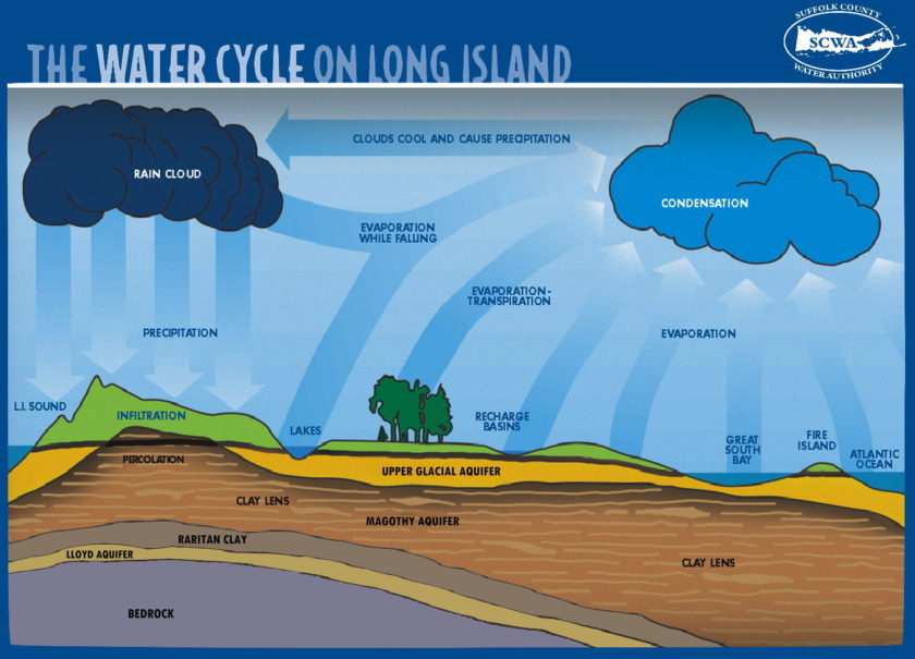
Digging a hole in the sand at the beach is a great way to illustrate the concept of how, below a certain depth, the ground is saturated with water. This upper surface zone of saturation is called the water table. The saturated zone beneath the water table is called an Aquifer, and the water in the aquifer is called groundwater. Aquifers are huge storehouses of water. Water in the Aquifer originates as precipitation (such as rain and snow), which slowly percolates down through the soil.
Long Island’s main source of drinking water is from the groundwater in this aquifer-making it a Sole Source Aquifer.
There are four primary formations which are layered and make up the Long Island Aquifer System. From the shallowest to the deepest, these formations are:
Depending on where you are located on long Island the depth to groundwater is different. The total depth of the Long Island Aquifer System is shallowest on the north shore (approximately 600 feet) and deepest along the south shore (approximately 2000 feet). Here is a map created by USGS of the depth to groundwater on Long Island: https://ny.water.usgs.gov/maps/li-dtw10/.
According to the USGS Estimated Use of Water in the United States in 2000, Nassau and Suffolk counties utilized more than 375 million gallons of groundwater per day for public, domestic, industrial, and irrigation uses.
The Long Island Aquifer can support future projections of water use for Suffolk County; however, the effects of water supply pumping on streams, ponds and wetlands that are fed by groundwater must be considered. In localized coastal areas projected water supply demands may exceed the limits of the shallow freshwater aquifer.
Additionally as development has increased on Long Island, the amount of water making it back down into the aquifer system has decreased. This is due to the increase in impermeable surfaces and operation of sanitary sewering systems that discharge to surface waters, instead of the natural process of re-entering the groundwater. Additionally, nitrogen, pathogen and toxin pollution can contaminate Long Island’s groundwater and present a public health concern.