Protecting & Restoring Long Island's Peconic Bays
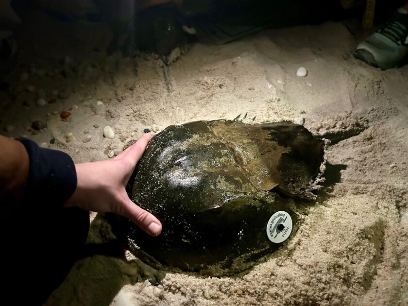
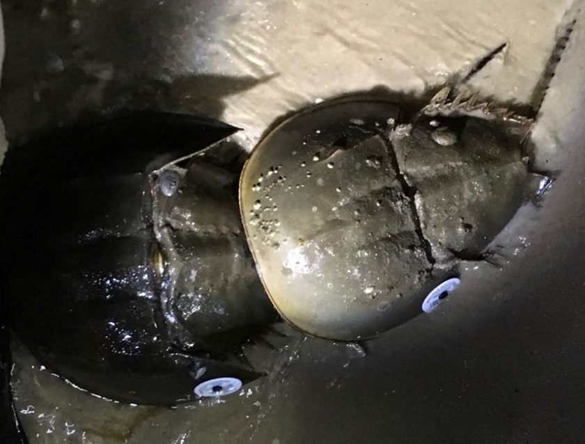
Project DescriptionHorseshoe crabs (Limulus polyphemus) and diamondback terrapins (Malaclemys terrapin) areimportant species that utilize the intertidal and subtidal habitats within the Peconic Estuary.(ASMFC 2020, Bopp et al. 2019). Both of […]

Project Description
Horseshoe crabs (Limulus polyphemus) and diamondback terrapins (Malaclemys terrapin) are
important species that utilize the intertidal and subtidal habitats within the Peconic Estuary.
(ASMFC 2020, Bopp et al. 2019). Both of these species are affected by similar ecosystem
stressors and are particularly vulnerable to the loss of these habitats, which are essential for
their deposition of eggs after reproducing (ASMFC 2020, Burger and Montevecchi 1975,
Feinberg and Burke 2003, Lovich et al. 2001). Shoreline hardening, sea level rise, and dredging
all present ever-increasing challenges to species reliant on adequate access to beach habitat
within the intertidal range or at higher elevations.
Both horseshoe crab and diamondback terrapin abundances within the Peconic Estuary are at
low levels. In the latest review of horseshoe crab population status, the Atlantic States Marine
Fisheries Commission (ASMFC) recently listed the status of horseshoe crabs in New York State
as “poor,” and data generated by the NYSDEC’s annual juvenile finfish trawl survey has shown a
dramatic decline in abundance of horseshoe crabs in the Peconic Estuary from 1987 to 2012
(Abruzzo 2015, ASMFC 2020). Additionally, CCE and NYSDEC’s annual horseshoe crab survey
indices of spawning activity indicates that spawning levels in the Peconic Estuary are the lowest
of all estuaries in New York State (Sclafani et al. 2020). Both horseshoe crabs and diamondback
terrapins are currently listed as “vulnerable” on the IUCN Redlist of Threatened Species, and
diamondback terrapins are also considered a species of “special concern” in New York State.
Furthermore, loss of salt marsh habitats; a required habitat of diamondback terrapins, are also
declining in New York State, and as a result local terrapin populations are declining (R. Burke,
Pers. Comm., Hofstra University).
Despite some annual spawning surveys, very little is known of the habitats that are used by
horseshoe crabs and diamondback terrapins for nesting throughout the Peconic Estuary
watershed. Having such information could help guide conservation policy for intertidal and
beach habitats with respect to shoreline hardening, sea level rise, and other factors. Modern
telemetry methodologies may be a useful approach to provide critical data about habitat use by
both species, and such technology may have potential to extend to other species of concern in
the future (Bopp et al. 2021, Brousseau et al. 2004).
CCE proposes a pilot-scale test of satellite telemetry technology to advance the monitoring of
diamondback terrapins and horseshoe crabs within the Peconic Estuary. In just the last few
years satellite tags have improved greatly with respect to their size, battery life, spatial accuracy
and the inclusion of additional environmental sensors (e.g. temperature, depth, etc.) that are
recorded simultaneously while tracking animals. Hence, these modern tags may now be
suitable to apply to aquatic species such as horseshoe crab and diamondback terrapins. CCE
staff will collect 5 adult female horseshoe crabs and 4 adult female diamondback terrapins by
hand from spawning/nesting sites within the Peconic Estuary between the months of May and
August. Each animal’s carapace will be tagged with either Wildlife Computers Inc.’s Argos
satellite tag, allowing for satellite telemetry tracking, or Lotek’s FastGPS satellite tag, allowing
for both satellite and GPS tracking for fine-scale accuracy and rapid data transmissions. Tags
will be attached using standard protocols and supplies recommended by Lotek and Wildlife
Computers Inc., and without causing harm to the animals. Once tagged, the animal’s location
and any other recorded data (e.g. temperature and/or depth) will be relayed via the Argos
satellite system each time the tag comes into contact with air, which will occur when the animal
either exits the water to nest or surfaces to breathe (in the case of diamondback terrapins).
These tags will also have the potential to indicate if an animal is captured offshore by trawl nets
or other fishing practices.
Argos satellite messages are automatically retrieved by secure web server and stored in a
secure cloud database for retrieval, viewing, and processing at any time. The temporal and
spatial data can be used to map habitat use as well as to provide a greater understanding of
behavioral metrics such as activity, home range, and site fidelity. Data will be processed into a
detailed spreadsheet and GIS database. All data will be made available to PEP in an Excel
spreadsheet format, and any photos and GIS layers produced will be provided to PEP. Data will
be interpretated and presented to PEP in a written report format. The efficacy of each type of
tag will be assessed and considered for use in future wildlife monitoring efforts.
This proposed pilot telemetry project will expand upon PEPs current wildlife monitoring efforts
through the Long Island Wildlife Monitoring Network by testing whether satellite and GPS
telemetry technologies are viable methods for tracking the movements of these key species
when they come ashore to nest. If successful, the preliminary data acquired from this project
could form the platform for future telemetry tagging studies that may yield high resolution data
across many temporal and spatial scales on habitat use by these species. Such a complex
dataset would allow for the identification of unknown and preferred nesting habitat of these
and other important species, allowing for a deeper understanding of habitat preference and
any obstacles or risks wildlife face while nesting. With this information, PEP and partnering
organizations will be better equipped to recognize monitoring gaps and strengthen the
development of a detailed estuary-wide habitat restoration and protection strategy. Such a
strategy will help PEP map out areas for restoration and protection based on their importance
to key estuarine species or risk of future inundation as a result of sea level rise and increased
shoreline hardening.
Contact Matt Sclafani for more information on this project.
Sign up for News, Events and Information straight to your inbox.