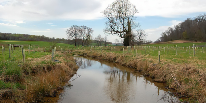
Forest and grass buffers are vegetated areas that can effectively buffer aquatic resources against direct nitrogen inputs by capturing runoff, promoting soil infiltration, and plant uptake (Phillips 1989) and physically separates a stream, lake, wetland, or shoreline from future disturbance or encroachment.
The creation of buffer zones is largely dependent on availability of land. For agricultural areas, crop loss may need to be factored into the cost of BMP implementation if excess land is not available. Opportunity costs for the loss of land or potential income from incorporation of cover crops are not included in the cost estimates for this assessment. While property values remain high, as discussed previously, this BMP does not anticipate extensive area nor the conversion of an area to wetland. Loss of potential income needs to be considered on a case-by-case basis based on crop use, amount, and value at time of assessment. It is encouraged that County, State, and Federal agencies that provide financial incentives for the creation of buffer zones be thoroughly reviewed as part of a site assessment for the cost benefit of this option.
Current and future flood risk, sea level rise (SLR), and current and future depth to groundwater should be considered in the evaluation of the appropriate NRB. In areas where the groundwater table is high under current or future SLR scSimilar to wetlands, grass and forest buffer zones should be located to intercept the maximum amount of agricultural drainage. Additionally, to maximize nitrogen removal, buffers areas should be downslope at a 4:1 upslope to buffer ratio (Belt et al. 2014).
Permitting would depend on the location and size of the surface runoff BMP, and may include the following:
The NRCS Environmental Quality Incentives Program (EQIP) program provides benefits for runoff BMPs, provided guidelines are followed. The Suffolk County Water Quality Improvement Division also promote stormwater quality improvements through the Water Quality Protection and Restoration Program and Land Stewardship Initiatives (WQPRP) grant funding program. New York State provides funding through the Water Quality Improvement Project (WQIP) Program.
The vegetation type of buffers is less important than the width of the buffer and hydraulic retention time; narrow buffers (less than 10- and less than 5-meter forest and grass buffers, respectively) are less effective at removing nitrogen than wide buffer zones and high hydraulic conductivity of the soil can decrease removal effectiveness (USEPA 2005). Soil properties and saturated soils promote nitrogen removal through denitrification in the subsurface (USEPA 2005).
The influent nitrogen concentration is based on the same assumptions described for wetland buffer zones. Nutrient removal efficiencies are based on the CAST recommendations for Outer Coastal Plain hydrogeomorphic regions (Chesapeake Bay Program 2018).
Drainage areas for 1 acre each of forest and grass BMPs are based on those used by CAST (Chesapeake Bay Program 2020) and nutrient removal estimates reflect the load estimated for these drainage areas based on the same impervious cover assumptions as the wetland scenarios.
Forest and Grass Buffer Zone Nitrogen Effluent Concentrations, Nitrogen Reduction, Drainage Area, and Annual Removal Rates
| BMP | Effluent Nitrogen Concentration (mg/L) | Nitrogen Reduction (%) | Drainage Area (acres) | Annual Nitrogen Removal (lb/yr) |
|---|---|---|---|---|
| Forest Buffers | 6.8 | 31 | 4 | 9.1 |
| Grass Buffers | 7.8 | 21 | 4 | 6.2 |
Forest buffer zone BMP capital costs are an average of the Riparian Forest Buffer Code 391 scenario construction costs (NRCS 2021) and grass buffer capital costs are based on an average of NRCS (2021) construction costs estimated for Filter Strips (code 393), Riparian Herbaceous Cover (code 390), and Field Border (code 386). Design and engineering costs are not included and assumed to be provided by NRCS. O&M costs are from CAST (Chesapeake Bay 2018) with a 2% inflation rate applied, and include costs for replanting, reseeding, mowing, and herbicide applications. The annualized total cost includes capital costs annualized over a 40-year for forest buffers, given the regenerative nature of this practice (Belt et al. 2014) and a 10-year lifespan for grass buffers, as they have a shorter life span (Belt et al. 2014), with a 5% discount rate and the annual average O&M cost. Costs are per 1 acre of buffer.
Forest and Grass Buffer Zone Capital, O&M, Total Annualized Costs, and Costs per Pound of Nitrogen Removed
| BMP Type | Capital Cost | Average Annual O&M Costs | Annualized Total Cost | Cost per Pound N Removed |
|---|---|---|---|---|
| Forest Buffers | $4,166 | $218 | $461 | $51 |
| Grass Buffers | $903 | $39 | $156 | $25 |